
A boat trip to see impact of three big floods
On July 18, a group of journalists took a cruise on the University of Vermont’s research vessel, the Marcelle Melosira, with a group of scientists, to hear and see what impacts flooding, and specifically the July 11 flood, have had on Lake Champlain’s water quality.
Although they do have some data, it’s too early to tell definitively what the impacts of the most recent flood will be, the scientists said, but what they know so far tells a story of expected degradation of the lake — with some bright spots.

Captain Taylor Resnick pilots the only hybrid vessel in the world. The Marcelle Melosira can travel for three hours on just its lithium-ion batteries.
“What we do on the land is very significantly impacting the water quality,” said Kris Stepenuck, the Lake Champlain Sea Grant’s associate director and extension program leader.
The watershed that drains into Lake Champlain extends as far east as Cabot, as far west as Saranac Lake, as far south as Rutland and into southern Quebec, Stepenuck said.
That’s a lot of land to worry about to try and keep the lake clean. That watershed is 19 times the size of the lake. As watersheds go, it’s an extremely large one. For comparison, consider that the watershed to the Great Lakes ratio is 2 1/2 to one.
There are more than 20 stations collecting water quality data from the lake, said Ryan Mitchell, the organization’s communications and publications coordinator.
It should not come as a surprise that, so far, the indications are that last summer’s flooding had much more impact on the lake than this summer’s.
Although this year’s flooding did much more damage in Charlotte, which in 2023 escaped mostly unscathed, the damage was much more widespread and impacted the total watershed much more last year.
“We had two very different meteorological events. Last year in July, we had kind of a high-pressure system collide with a low-pressure system and that moisture just sat over our region for 48 hours, a very slow-moving storm,” said Matthew Vaughan, chief scientist with the Lake Champlain Basin Project.
Last summer’s storm dumped 4-9 inches of rain over a vast area, while this year’s storm was very different.
The remnants of Hurricane Beryl, which hit us a couple of weeks ago, did bring similar amounts of rain in some regions, like Charlotte, which received around 6 inches this year and in a very short time. Consequently, it was much more intense here.
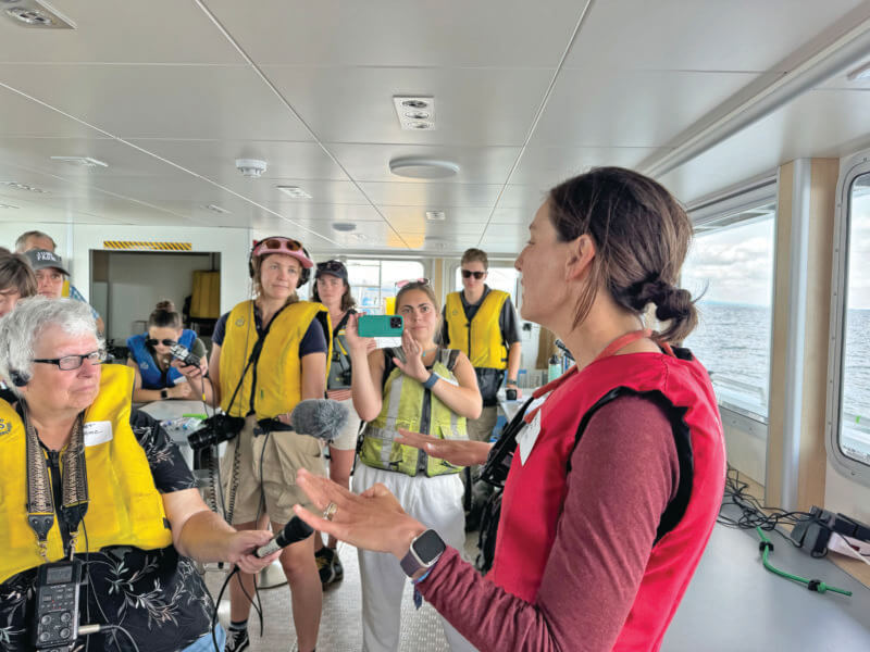
Rebecca Diehl tells the gathered journalists on the Marcelle Melosira that what’s best is “inefficiency in our watershed.” Rather than dredging streams and rivers to make the flow faster, the best thing for the lake would be if water moved more slowly.
So, we had higher intensity, greater amount of rainfall falling through time in a smaller amount of area,” Vaughan said. “That’s why we saw the damage and the devastation really more concentrated in our higher, steeper streams.”
Although the event this year is expected to have significant impact on Lake Champlain, it should not have as much impact as last year and be less widespread, he said.
On July 11, 2023, Vaughan said the Winooski River, the largest tributary to Lake Champlain, was at the highest flow seen since 1990, when the Lake Champlain Basin program was created by an act of Congress and the organization’s monitoring of the lake began.
This July’s flooding produced a flow that was only the tenth highest the organization has seen. However, the flooding this December 2023 produced the fourth highest flow in the Winooski that the Lake Champlain Basin program has measured. So, three of the 10 highest flows in the Winooski River in the organization’s more than 30 years of measuring have come in a year’s time.
In December, according to VTDigger, Gov. Phil Scott said the flooding that came in the midst of the holiday season, just five months after the previous flood, was “a real gut punch.”
Last July, the flood deposited about half the amount of phosphorus the lake can handle in a year and still meet its total maximum daily loads, or TMDL, the maximum daily loads of a pollutant that a body of water can tolerate and meet water quality standards.
Vaughan said he is still working on the figures for this July’s flood, but because the overall flow into the lake this July was about two-thirds of the flow last July, they expect the phosphorus dumped in the lake by the flood to be lower this year.
Last year, the lake rose by three feet after the flood. This year, it’s still rising, but it’s gone up by about a foot and half so far.
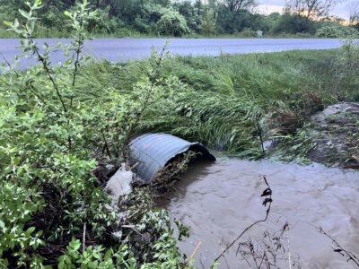
“The most immediate impacts to lake water quality is something we can all see with our eyes — the decrease in water clarity,” Vaughan said. “When waters are running high, they’re very turbid.”
Turbidity is a measure of how murky it is because of sediment being suspended in the water. Increased suspended sediment is expected to continue mixing in the lake for one to three weeks, he said.
Turbidity is measured with a Secchi disk, a black-and-white disk that is lowered into the water to see how deep it can go and still be seen from the surface. Anna Hoppe, who has an agroecology fellowship with the University of Vermont, demonstrated how the measurements are made.
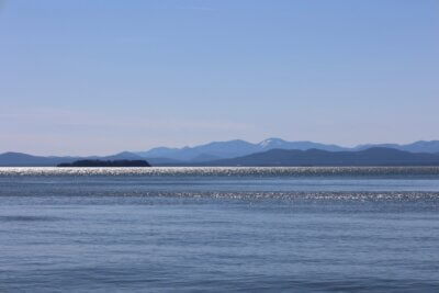
The research vessel traveled just past where the Winooski dumps into Lake Champlain, and the light brown turbid water of the river was easy to see in the clearer water of the main body of the lake.
Last year, it took about two weeks for turbidity to drop and clarity in the water to rise. Monitoring of the water is about in the middle of the process, so it is still to be seen how long it will be before the water returns to normal.
“The turbidity level was about three times higher at its peak last year than the peak we’re seeing this year,” Vaughan said. “Although it’s a significant event, it’s about a third of what we saw from the drop in water clarity compared to last year.”
Weather Service records date back to the 1850s and Hurricane Beryl is the earliest Category 5 hurricane in those records. The early appearance of such a strong hurricane can be tied to climate change and increasing air and ocean water temperatures, Vaughan said.
“In the past, the highest flows to the lake would be in the springtime when the snow is melting. That’s kind of a natural cycle, but what we’re seeing now, due to climate change, is more precipitation falling as rain rather than snow,” Vaughan said.
Now, we are seeing higher flows in the winter and a decrease in spring because of less snowpack to melt. This leads to more intense, more frequent and extreme rainstorms in the summer and fall.
The beginning of this story promised some good news. Well, Vaughan said he was surprised and encouraged by how well the lake recovered from last year’s flooding.
“We had a huge input of phosphorus from last year’s storm and the December storm,” he said. “What we saw was an increase in the short term in phosphorus, and then a recovery over the next few weeks, where things looked more like normal.”
Related Stories

Popular Stories
If you enjoy The Charlotte News, please consider making a donation. Your gift will help us produce more stories like this. The majority of our budget comes from charitable contributions. Your gift helps sustain The Charlotte News, keeping it a free service for everyone in town. Thank you.
Andrew Zehner, Board Chair