


Calling all landowners—we need your help
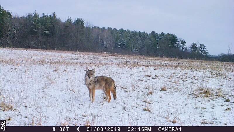
The Charlotte Conservation Commission has acquired several trail cameras to help identify and confirm key significant habitat corridors in town. These cameras will help us in two ways: first, to aid in evaluating the impact of proposed significant development projects, and second, to confirm wildlife hotspots and connectivity corridors. Using only game cameras to collect data is not very reliable since the data points are somewhat arbitrary in space and time. However, in conjunction with the existing Charlotte Significant Habitat Map, state data and a baseline of trail camera data throughout Charlotte, the cameras can be a powerful tool.
That’s where you come in. In order to establish a baseline of what is considered low, medium or high habitat value, we have randomly identified 100 points throughout Charlotte using GIS software. Of those 100 locations, we would like 20 property owners to allow us to put a trail camera on your property in a mutually agreed upon place for two weeks. Ideally, we’ll end up with a mix of small and large parcels, with forests, fields and development. By randomly selecting locations as opposed to targeting suspected high-traffic areas, we’ll begin to understand the species and number of individuals that constitute a baseline—those that would be expected to be seen anywhere versus those that require specific habitat to survive.
If you’re willing to have a trail camera on your property, please contact us with your name and address. If you match up with one of the randomly identified 100 points, we’ll install the trail camera at an agreed upon time between June and September. The Conservation Commission expects this to be an ongoing project. Currently we are developing a protocol for calibrating the cameras, deployment and retrieval, and handling data based on similar trail camera studies. All pictures will be shared with property owners and posted on a cloud system for sharing photos with landowner permission.
The Conservation Commission meets the fourth Tuesday of the month. All are welcome.
Related Stories


Popular Stories
If you enjoy The Charlotte News, please consider making a donation. Your gift will help us produce more stories like this. The majority of our budget comes from charitable contributions. Your gift helps sustain The Charlotte News, keeping it a free service for everyone in town. Thank you.
Andrew Zehner, Board Chair