
The scoop on local trails
Enjoy a stroll in our beautiful town!
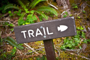
Every few years I revisit the inventory of walking trails in Charlotte. Our town is blessed with these resources and the vast network of volunteers who support them.
 Straddling Monkton, Hinesburg and Charlotte, Raven Ridge is a 362-acre Nature Conservancy preserve encompassing wetlands, bobcat dens and migration corridor, nesting areas for ravens, three state-significant forest communities, and an anticline, a unique geological feature known locally as The Oven. Vernal pools provide breeding habitat for wood frogs and spotted salamanders. Take Roscoe Road south to end. Turn left onto Rotax Road, go 0.5 mile to small parking area. An upper loop trail rises from a boardwalk that crosses the wetland. Total round trip is about 2.5 miles. No pets. Map at The Nature Conservancy-Vermont website.
Plouffe Lane Trail, 1.4 miles, easy to moderate, on 80 acres of town-owned land along the LaPlatte River in East Charlotte. Meadows, fields and views of the Green Mountains. Plouffe Lane is off of Carpenter Road, east of Spear Street. Parking and picnic table near trailhead. Follow Plouffe Lane to the end (there is a red gate), open the gate, and park your car inside.
Charlotte Park and Wildlife Refuge, also known as the Demeter property, 3.1 miles of easy to moderate trails for pedestrians and horses on 290 acres of farmland, succession woodlands and wetlands. A series of loop trails rise more than 200 feet to expansive views of Lake Champlain and the Adirondacks. Parking lot on the east side of Greenbush Road, 1.3 miles north of Ferry Road. No access from Route 7. Open daily from 8:00 a.m. until a half hour after sunset. No pets.
Pease Mountain, a 2.6-mile network of easy to moderate trails that includes a UVM Natural Area. Lower and upper loops are marked as are two spurs that lead to expansive views. A trailhead sign details Pease’s natural history and has an excellent map. Pets must be leashed and on the trails at all times. Please clean up after them.

Williams Woods, 1.2-mile loop, easy. Williams Woods is a Nature Conservancy preserve, an island of trees amidst farm fields. A boardwalk keeps visitors above often-waterlogged soil and the tangle of roots that grow above ground. The trail weaves beneath giant hemlocks, old oaks and white pines. Look for a Nature Conservancy sign on the west side of Greenbush Road, one mile south of Thompson’s Point Road. Park at roadside. No pets.
Mt. Philo, Vermont’s oldest state park offers year-round access to views, recreation and geology. The park sits on a 968-foot sheep back mountain rising abruptly from the Champlain Valley. Both an asphalt road and hiking trails climb to the summit overlooking Lake Champlain and the Adirondacks. Trail improvements are ongoing, and updates on construction are posted in a kiosk at the base. Mt. Philo Road at State Park Road. Admission charged mid-May to mid-October, 8:00 a.m. to sunset. Pets must be leashed.
With several completed sections, the Town Link Trail is “live” between Mt. Philo and the north end of the Cohousing on Greenbush Road. This includes an underpass beneath Route Seven. Another segment meanders just south of the West Village.
Beginning at the base of Mt. Philo and across from the entrance to the state park, a crushed gravel path rolls gently beside, and separated from, State Park Road from Mt. Philo Road to the Melissa and Trevor Mack Memorial Trail. The latter runs through farmland and passes a vineyard as it reaches the Route Seven underpass in 0.7 mile. Parking available on Lower Old Town Trail. The Cohousing section continues west from the underpass through fields and woodlands before arriving at Common Way, where there is limited parking in designated spots.
The Village Loop Trail combines several sections. From a parking area just off Route Seven, a wide trail leads through the woods to a large meadow east of Greenbush Road. Two narrower and more rugged walking paths run slightly north, through the woods, also reaching the meadow. Mowed paths continue to Greenbush Road, crossing it just south of the Old Lantern where there is additional parking. A mowed trail climbs Barber Hill along the southern fence line. The top of Barber Hill (384 feet) provides views of Charlotte’s West Village, Pease Mountain and Church Hill. The mowed path descends toward the Old Lantern. Continuing north across private property—please respect signage and landowners’ privacy—the trail passes through a wooded section enroute to Ferry Road, where the Village Loop Trail currently ends.
Maps can be found at Trail Finder, or the Town of Charlotte.